OBAMA NEXT information products
Information products (IPs) developed.
Coastal Vegetation Mapping Using Remote Sensing
High-resolution drone-based mapping of coastal vegetation, including in situ ground truthing, model training, testing and validation.
Read more about this topic on OBAMA NEXT project website.
IP1 - Seagrass mapping – distributions and ecological status
Drone-based seagrass mapping, including in situ ground truthing, model training (ML), testing and validation. The code repository is hosted at the SeaBee github organization here
IP2 - Coastal vegetation mapping – upscaled from drones to satellites
Fusion of high-resolution, small scale drone data and lower-resolution, large scale satellite images for upscaling of coastal vegetation maps (macroalgae, seagrass, bivalves, etc.). The code repository is hosted at the SeaBee github organization here
IP26 - Mapping of biomass and carbon content of coastal vegetation using green LiDAR on drones
The use of LiDAR technology to precisely estimate the volume and biomass of submerged vegetation (seagrass, macroalgae, etc.) in the coastal zone. Carbon stock can be estimated. Compared to other drone products that are using RGB and MSI sensors (see IP-1 and IP-2), LiDAR’s can deliver volume data of vegetation from distribution and canopy height. Going from 2D (see IP-4) to 3D gives a more detailed and accurat estimat of the above-ground carbon stock of important species and habitat types, such as seagrass meadows, macroalgae beds, and kelp forests. The volume of these habitats are also tightly correlated to other ecosystem services, such as coastal protection and biodiversity. The code repository is hosted here
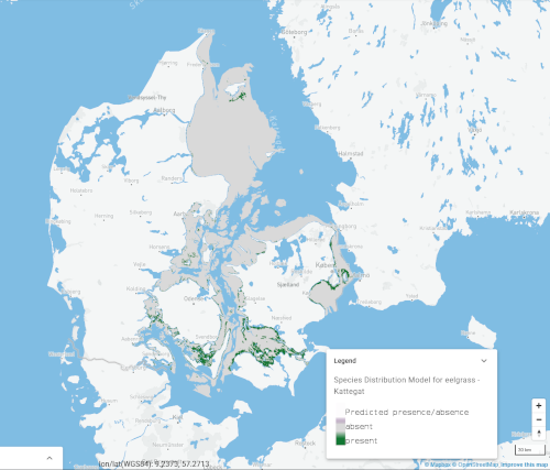
IP43 - Eelgrass SDM
A map predicting distribution of habitats of important WFD indicator species Zostera marina in Danish waters. Based on Machine Learning statistical approach (Random Forest model) using data layers including eelgrass coverage data from Danish monitoring program together with environmental data layers such as maximum wave exposure, temperature, light at seabed and Sediment. The code repository is here
The modelling results are available on the OBAMA-NEXT data viewer here
Species Distribution Models for Threatened Habitats and Species
High resolution spatial predictions on the occurrence of threatened species.
Technologies: Machine Learning, Statistical Modelling, In situ data collected by divers and drop-video
Relevant to Policies: Habitats Directive, Marine Strategy Framework Directive, European Biodiversity Strategy, Global Biodiversity Framework
IP9 - Population estimates of seabirds based on drone images and object recognition (AI/ML)
Population estimates of seabird colonies, including information on species, age, sex, nesting status, and feeding activity. To replace ineffective methods using airplanes and manual bird counting. The code repository is hosted at the SeaBee github organization here
Habitat Suitability Modelling of Marine Mammals
Maps of habitat suitability and use for these marine mammal species can show how ecosystems respond to environmental change and the effectiveness of conservation actions.
Read more about this topic on OBAMA NEXT project website.
IP18 - Porpoise SDM
The code reads the harbour porpoise tracking data (based on ARGOS tags), cleans the Argos data, and performs a MaxEnt analyses to generate habitat suitability layers for one season and period (out of 6). Raster data is based on Copernicus data, which is freely available but also provided in the raster folder. To generate habitat suitability layers for all season and periods described in the article, adjust the code to the season and period of interest and rerun the procedure. See the code here.
High-Resolution Predictive Maps of Processes Underlying Fish Reproduction
The model integrates different types of fisheries and survey data and returns estimates of how different processes underlying animal’s reproduction cycle are affected by environmental conditions at a local scale, as well as predictive maps of animal and underlying reproduction processes distribution along the area of interest. The model applies to the Baltic whitefish.
Read more about this topic on OBAMA NEXT project website.
Detecting and Quantifying Macroplastic on Beaches using Drones and AI
This IP describes how drones equipped with advanced sensors can be used to detect macroplastics on beaches. Artificial Intelligence is used to quantify the amount of litter, for instance before and after a beach clean-up event. The SeaBee drone infrastructure has done proof-of-concept studies on this, which still remains to be included in monitoring.
Read more about this topic on OBAMA NEXT project website.